Galdhøpiggen Photo by Christian Roth Christensen – Visit Norway

Galdhøpiggen

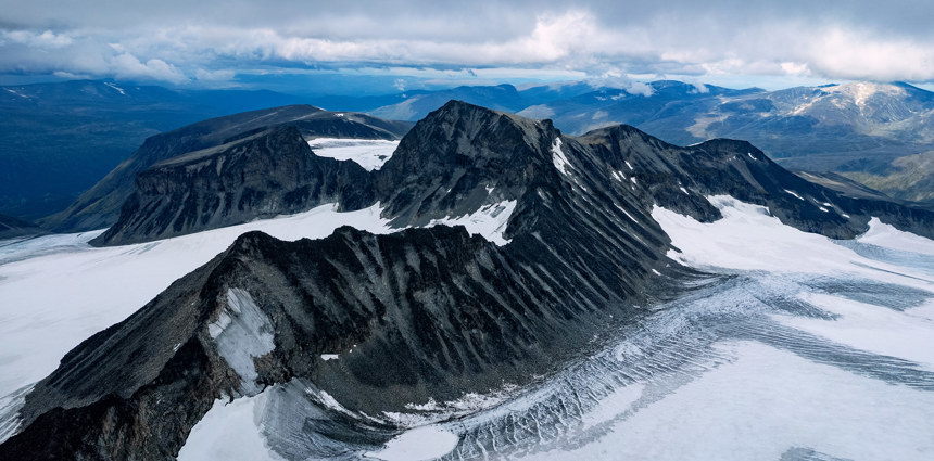
To sit on top of Jotunheimen, you’ll have to conquer a 2469m (8,100ft) rise above sea level first. You’ll be rewarded with a 360 degree panorama of Jotunheimens mountain and lakes.

Hiking: Galdhøpiggen

Elevation at peak: 2469 meters

About Galdhøpiggen

Galdhøpiggen can usually be climbed in three ways from Spiterstulen: Easy, Hard and Extreme

It runs fine from Spiterstulen with "young hikers" down for 5-6 years old if they are motivated. We go to the top with school kids 6-7 years each week. Otherwise, it is worth mentioning that it also runs an easier ride to the top of Juvasshytta, but when you are dependent on the mountain guide and the equipment includes a glacier requires.

On your own

The tour starts in the woods, it leads you to the top of the mountain and Norway! Such ascent providing wonderful variations both in terrain and views. It is worth mentioning that the tour not only reaches one, but three peaks over 2,000 meters! Across the bridge at Spiterstulen and slightly to the right. Where you follow a clear path, it is renovated by Sherpas in 2010 because of high attrition, and we ask why people follow the signs. Moreover, one goes over a relatively decent area. before you have to grapple with some loose gravel. After the gravel is a nice climb over snow and watches before rounds Svellnose. When then get to the bottom of Kailhaus top, one can lose a little "pep" but this is a wonderful slope! On top you can see over the top of the goal - Galdhøpiggen and see that it is achievable! Slightly down and last climb is that aløtid heavy but rewarding. On top you can see 1/4 of Southern Norway on a nice day!

With mountain guide

This is the trip you ever take a lead from Spiterstulen. The tour starts at the farm, which they all do ... Over the bridge and to the left, then follow the trail to Svellnosbreen up to the glacier's edge. Here, the trip may differ slightly from a regular glacier because here you have to take into account conditions. While those going on the glacier goes for a walk in the icefall, you choose to have a different maybe shorter walk through the formations for this trip. Then you go over the flat glacier before arriving GALDHØPIGGEN feet! Here there is a well-deserved break before really climbing the top with about 400 meters in one hour! A great way to reach the top on!

Extreme

This is the tour for trained mountaineers. Adhering to that of the glacier, but on top of the moraine break off towards the front Tverråtind. Then the trip goes around and up on this before you follow the ridge around Tverråtindane - Ymelstind - Storjuvtinden before landing at Galdhøpiggen and down again on Kailhau and Svellnose (there are 8 of 2000 on a trip ...) This tour will typically require a few abseil so it may be smart to talk to guys in reception at Spiterstulen.

Climbing

It is possible to climb to the top of the "Gateway", but we recommend a good knowledge and climbing guide for this. It provides its own freedom and mastery which is incredibly nice. But we want to refer to courses and Climb Driver for Jotunheimen who can be bought.
History

Geologically, Galdhøpiggen belongs to the Caledonian folding, like most of Southern Norway's mountain ranges. The peak is made of gabbro, a hard but rather coarse-grained rock which is found in most of the Jotunheimen range. During the ice ages it was heavily glaciated and got its present form. The theory that the highest summits in Norway stayed above the ice as nunataks has been abandoned by most geologists. It fits well with the present flora in the area, but it does not fit well with the present knowledge of ice thickness and the results of glaciation.

For many years, geologists did not know that Galdhøpiggen was the highest summit in Norway. The honor was granted to the much more visible Snøhetta in the Dovrefjell range. Hence no attempts were made to climb the peak, while Snøhetta was visited for the first time in 1798 as part of a scientific trip to the area. In 1844 the geologist and mountaineer, Baltazar Mathias Keilhau, made two unsuccessful attempts to reach the summit. On one of these he reached a summit, which was later named Keilhaus topp (at 2,355 m above sea level very close to Galdhøpiggen), but the terrible weather forced him to return.

In 1850 three men from Lom reached the summit; the guide Steinar Sulheim, the local teacher Lars Arnesen and the church warden Ingebrigt Flotten

Galdhøpiggen Photo by Christian Roth Christensen – Visit Norway
Besseggen (Memurubu ↔ Gjendesheim)

The popular Besseggen ridge is a route route of about 6-8 hours (breaks included). The Besseggen hike takes you over the spectacular, steep, and some places very narrow trails which plunge four hundred meters straight down into the lake below. Read more

Besseggen (via Bessvatn from Bessheim)

Hike the famous Besseggen ridge on this alternative route from Bessheim. The route is a little longer but with less height meters to ascend. Read more

Bitihorn

Bitihorn at 1607 meters above sea level is one of the classical and easier hikes suited well for beginners in the area. The route start at the doorstep of Bygdin hotel and takes you up to a fantastic panoramic view over Valdres. Read more

Bukkelægret: Memurubu ↔ Gjendebu

Bukkelægret has a steady steep climb/descent on both sides of the route, with a longer flat plateau in the middle. The hike will take you through a variety of beautiful trout-filled lakes – a great place to catch your lunch. The high mountain offer great views of Gjende. In the steepest a Read more

Bygdin ↔ Torfinnsbu

Hike along the shore of the Bygdin lake. Hike one direction and take the M/B Bitihorn boat the other way. This way you get a mountain cruise and a great hike. The extra time you can spend at Bygdin Mountain Hotel and enjoin their famous waffles. Read more

Galdhøpiggen via Svellnosbreen

This is a longer, but much more exciting route to the summit of Galdhøpiggen, 2469 meters above sea level. The route includes a spectacular glacier crossing and steep, but easy scrambling up the south face of Galdhøpiggen. We follow the normal route down to Spiterstulen. It is a demanding trip Read more

Gjendetunga (From Gjendebu)

Gjendetunga is the perfect hike for those who want to indulge in a nice, relaxing and shorter trek, but who doesn’t want to go without a panoramic view experience. Towering over Gjendebu, Gjendetunga lies at 1516 MASL (4973, 7 feet) and is “a not to miss” hike if you’re in this area. On c Read more

Glacier hike to Svellnosbreen

A glacier tour to Svellnosbreen is a spectacular experience with large crevasses and blue ice towers. This is a day trip starting from Spiterstulen at 10:00 and we arrive at the edge of the glacier around 12:30 where we put on the gear needed for glacier travel: rope, harness and crampons. We exp Read more

Glittertind

– At 2,457 m above sea level, Glittertind is the second highest mountain in Norway, located within the municipality of Lom. It’s easy to grasp why the hike to Glittertind is so popular; not only is it an exciting hike that takes you over a glacier, which in itself is reason enough to go, b Read more

Hjelle - Vetti Gård

Vetti can be reached by foot or by horse-carriage from the nearby Hjelle farm to the south. The scenic route between Hjelle to Vetti Gård is well marked and is more like a well groomed road than the normal trails we are used to in Jotunheimen. Vetti is no longer regularly inhabited, but it is no Read more

Knausehøgdi

Enjoy hiking through the scenic mountain terrain with views of Jotunheimen and Langsua National Parks. Read more

Knutshøe

Next to his bigger brother Besseggen, you will find the 1517m high peak of Knutshøe. Knutshøe offers outstanding views towards the peaks towering all around and the surrounding lakes. Read more

Kvitskardtinden

With its 2,193 meters above sea level, Kvitskardtinden is Norway’s 59th highest mountain. Great views over Svartdalen bellow and Jotunheimen in the background! Read more

Kvitskardtinden (From Torfinnsbu)

With its 2,193 meters above sea level, Kvitskardtinden is Norway’s 59th highest mountain. Great views over Svartdalen bellow and Jotunheimen in the background! Read more

Melbyfjellet

From Beitostølen you can hike to Melbyfjellet past old mountain farms and the green mountain pastures with the views of Jotunheimen and Langsua National park. Read more

Nørdre Kalvehølotinden

North (Nørdre in Norwegian) Kalvehølotinden, with its 2019 meters above sea level, is the southernmost of Norway’s 2000-meter peaks. The mountain is part of a ten-kilometer-long mountain massif called Kalvehøgde, which consists of ten peaks over 2000 meters, including Vang and Valdres’ hig Read more

Ridderspranget (The Knight’s leap)

Ridderspranget (The Knight’s leap) is a narrow gorge through Sjodalen in the river Sjoa. Ridderspranget is easy to get to, with a drivable road which turns off road 51, 5 km south of Randsverk. From the car park it is only a short walk to the gorge. Please don´t try to jump across the gorge. I Read more

Svartdalen (The Black Valley)

The popular hiking route from Torfinnsbu to Gjendebu takes you through Svartdalen, meaning “The Black Valley”, which is often referred to as the most beautiful valley in Jotunheimen. As you wander through this lush valley, you'll be surrounded by majestic towering peaks, several of which Read more

Synshorn

Synshorn at 1457 meters above sea level invites to a fantastic view of Jotunheimen. The trail is easy to follow and climb, and varies from soft terreng to rock closer to the peak. The hike is well suited for beginners and is a short hike starting at the doorsteps of Bygdin Hotel. Read more

The King’s Road: Eggum Gard - Borgund Stave Church - Selto

Are you ready to walk to the most famous sections of the King's Road across Filefjell? You will experience Vindhellavegen, Øygardsvegen and Galdane. You will also be able to visit the world known attraction Borgund Stave Church. Read more

The King’s Road: Kvamskleive - Øye - Tyinkrysset

Start your hike at Kvamskleive and continue like the locals with public transportation from the end of Kvamskleive to Øye. Or skip the first part to start directly at Øye to avoid any extra transportation. Kvamskleive was in use from 1808 and replaced an older road on the other side Read more

The King’s Road: Maristova - Borgund - Eggum Gard

The stretch between Maristova and Borlaug is 7 km long, and has an elevation of 300 metres. Most is on grassy track and is the original Kongevegen. If you start at Maristova and head west, you will immediately encounter the spectacular wooden bridges – all built according to instructio Read more

Torfinnsbu ↔ Eidsbugarden

The Torfinnsbu to Eidsbugarden route is also the last stage of the Historical Hiking Route in Jotunheimen. The route takes you west from Torfinnsbu to Eidsbugarden. The trail goes along Bygdin lake, climbing to as high as 1600 meters above sea level, and back down to the final destination at Eids Read more

Torshammaren (From Eidsbugarden)

The tour to Torshammaren will provide a feeling of being surrounded by Jotunheimen's mountain peaks. At the peak you will find yourself at the gates of Jotunheimen's wilderness. The tour is easy, and a great tour for beginners. There are only 370 height meters from start to the peak, with a fairl Read more

Tyinkrysset - Kyrkjestølen - Maristova

Large parts of the route follow the beautiful lake Otrøvann. The lake is also known as Støgovatnet, and is located 971 m a.s.l. Between Kyrkjestølen and Maristova, you will cross the actual Filefjell and reach Kongevegen’s highest point. The stretch across Murkløpphøgda is Read more

Utsikten (From Eidsbugarden)

Utsikten is a short, easy tour with spectacular view over the great nature landscape of Jotunheimen. Its about 410m height meters to ascend, but short and fits beginners well. Read more

Veslådalen (Gjendebu → Eidsbugarden)

The hiking route between the Gjendebu and Eidsbugard takes you from Lake Gjende to Lake Bygdin through Jotunheimen National Park. Starting off from the birch forest by Gjendebu you follow the Veslådalen valley before heading down to Lake Bygdin and Eidsbugard. The hike is long but moderate wi Read more

Vetti Gard - Vettifossen peak (Round-trip)

Vettisfossen is one of Norway's tallest waterfalls, and the 284th tallest in the world. Most people hike to the base of the waterfall for a view of Vettisfossen. It's also possible to hike to the top. The route and climb is longer than to the base. But while you are at Vetti Gård this is a great Read more

Vetti Gård - Vettisfossen (Round-trip)

Continue from Vetti Gård up into the beautiful Utladalen. The green wild nature and the river along the hike creates a superb scenery all the way on to Vettisfossen. With a free fall of 275 metres, Vettisfoss is the highest waterfall in Norway which has not been regulated. The short hike has som Read more

Vindhellavegen & Borgund Stave Church

Vindhellavegen combined with Borgund Stave Church is the most spectacular and famous part of The Kings Road. The hike was renovated by the Kings Road project and is not a superb hiking route. Read more